Key Points – Wednesday, April 26, 2017:
Synopsis: Good Wednesday morning! The eastern portions of Zone 8 will continue to get pounded over the next 5-7 days with heavy rainfall. Speaking of rainfall, rains moving east across Zone 8 this morning with those rains continuing east throughout the day. Watching for strong to severe storms capable of producing very heavy rainfall across southeastern Missouri today as well well…can’t rule out some flash flooding with tons of moisture being flooded in. Much cooler than normal temps expected as we go throughout the week into the weekend, some frost on vegetation remains possible especially across northern and western Zone 8 locations. We discussed in the video the differences in snowfall totals via data with the weekend system moving through, there may be some heavy wet snow falling at times but we are not expecting much to accumulate because of how warm surface temps will be. So as you can tell, a lot going on in the forecast, if you have any questions please let us know!
- Current Radar:
- Simulated radar from the RPM today…storms intensify later this afternoon into tonight across the eastern half of Missouri bringing strong to severe storms and localized very heavy rainfall…can’t rule out some flash flooding as well. Meanwhile, folks across Kansas, Nebraska and most of Iowa stay dry.
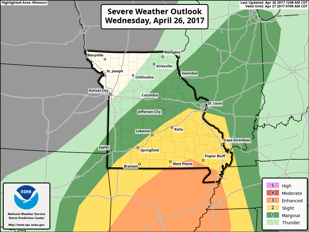
- Strong to severe storms today: the main threats being damaging winds and isolated large hail…can’t rule out an isolated tornado.
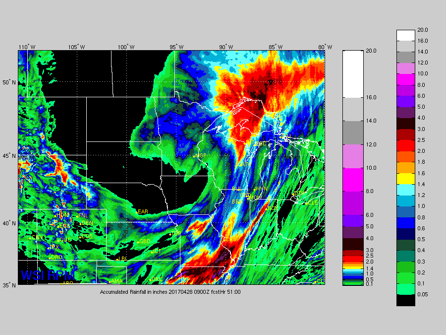
- Total rainfall over the next 51 hours: Folks across Missouri will feature most of the heavy rainfall here with 2-3″+ possible, meanwhile more dry time is expected across Nebraska into Iowa, with some hit or miss showers possible across far southern Nebraska, northern Kansas into southeastern Iowa.
- As we’ve been discussing all week, a warm front is expected to lift north into Zone 8 late Friday into Saturday bringing very heavy rainfall and potential strong to severe storms during this timeframe, and then a cold front develops later Saturday into Sunday sweeping east across the Eastern half of Zone 8 bringing gusty winds and additional heavy rainfall.
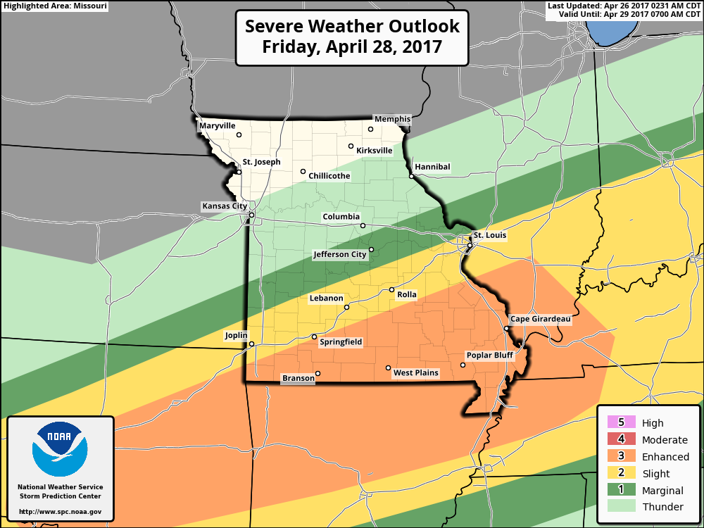
Strong storm risk…all modes of severe will be possible along the warm front Friday night into Saturday…with the main threats being damaging winds and isolated large hail…as well as very heavy rainfall.
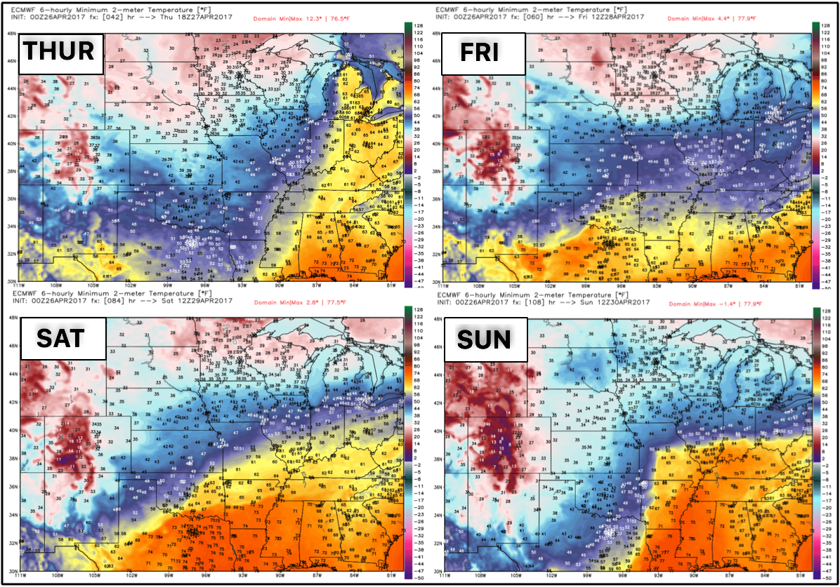
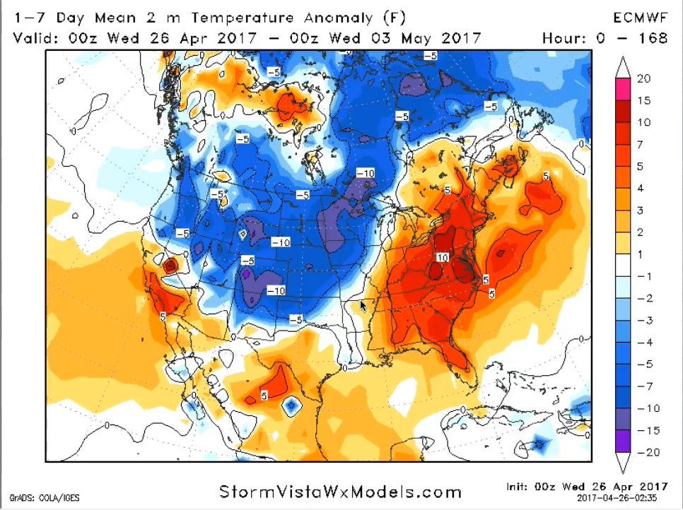
- Another story not getting enough attention is how cooler than normal we’ve been and will continue to be as we head into the weekend with 30s expected across Nebraska/Iowa Thursday and Friday, and then even cooler than normal temps expected Saturday and Sunday across Nebraska, Iowa into western Kansas.
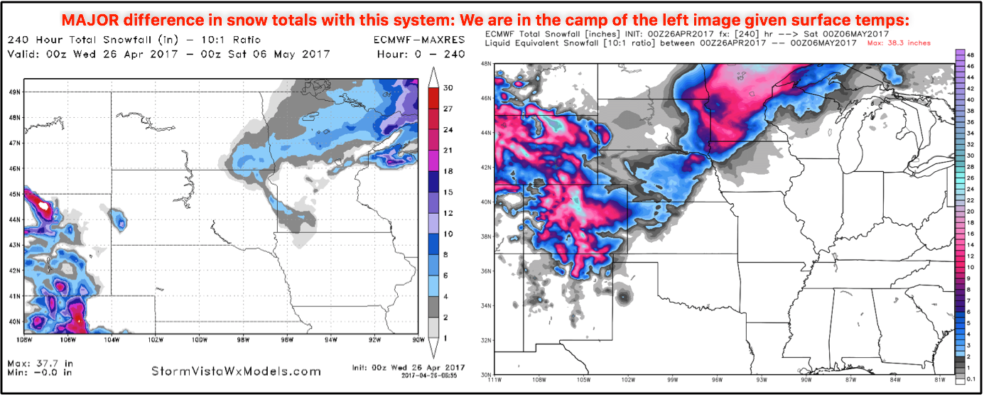
There’s been some discussion on social media about a big time snowmaker across the Plains, as you can see below there’s big discrepancies in the data even among the same model (using the Euro below). We side with the left image from StormVista because the accumulation amounts are based on surface temps, the right image from Weatherbell bases snowfall accumulation on upper air temps. The reason why we choose the surface temp-based accumulations amounts which are much lower is because of how warm (34º+) we are at the surface. Not expecting much to accumulate on the surface at this time Sunday into Monday.
Rainfall totals over the next 7 days via the European model, very heavy rainfall expected across Missouri with 4″+ possible especially southeast, meanwhile the northern half of Missouri, eastern Kansas into portions of southeastern and southern Iowa could see 2-3″ as well.
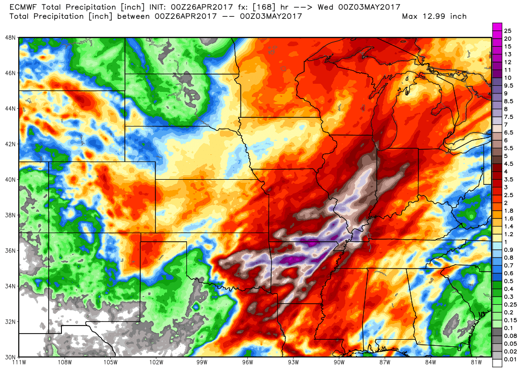
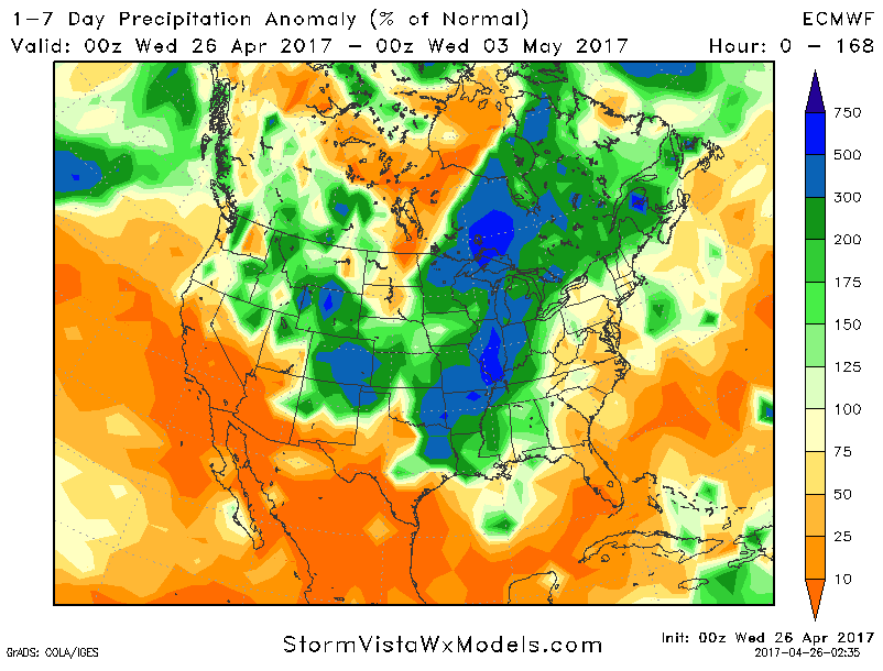
To put this into perspective, that is the equivalent of 3-500% the normal rainfall over the next week across southern Missouri, with 150-200% the normal possible across eastern Kansas, northern half of Missouri into southern Iowa.
As discussed above, much cooler than normal temps expected over the next 7 days across Zone 8…can’t rule out some frost on vegetation unfortunately as we get into May especially the further north your location is.
Confidence and Risk:
- Above average confidence heavy storms possible especially across southeastern Missouri today into tonight.
- Average risk for all modes of severe as well across the same area tonight, with the main threats being heavy rainfall, damaging winds and isolated large hail.
- Above average confidence additional heavy rainfall will be possible across Zone 8 as a warm front lifts north later Friday into Saturday.
- Average risk here as well for some strong storms being damaging winds, isolated large hail and isolated tornadoes.
- Above average confidence a cold front sweeps east late Saturday into Sunday mainly across the eastern half of the Zone 8 bring gusty storms and additional heavy rainfall.
- Average but increasing confidence of temps dipping into the 30s across portions of the northern and western Zone locations into the week…can’t rule out some frost on vegetation into May.
- Above average risk to snowfall accumulating this weekend as surface temps will be very warm to have stuff stick.
Today’s video (8 min):