Key Points – Wednesday, March 29, 2017:
Synopsis: Good Wednesday morning! Below you will notice a new feature we unveiled today called a “Quickcast”, it’s a great way to get a general idea of the weather conditions over the next 3 days. Let us know what you think of them! Showers and storms continue across the eastern half of Zone 8 today, with even severe storms possible across eastern Kansas to Missouri…we have a risk for damaging winds, isolated large hail and even tornadoes especially across Missouri. The showers and storms threat shifts east on Thursday into Iowa and Missouri…with a few residual strong storms possible including gusty winds and isolated large hail. Overall we are forecasting the potential for very heavy rain in some locations that could exceed 3″ over the next 48-60 hours…which is good news for the dry hard red winter wheat crop locations. We don’t wait long for our next chance for inclement weather as more rain is forecasted this weekend into early next week. The pattern stays extremely active into April. Have a wonderful Wednesday!
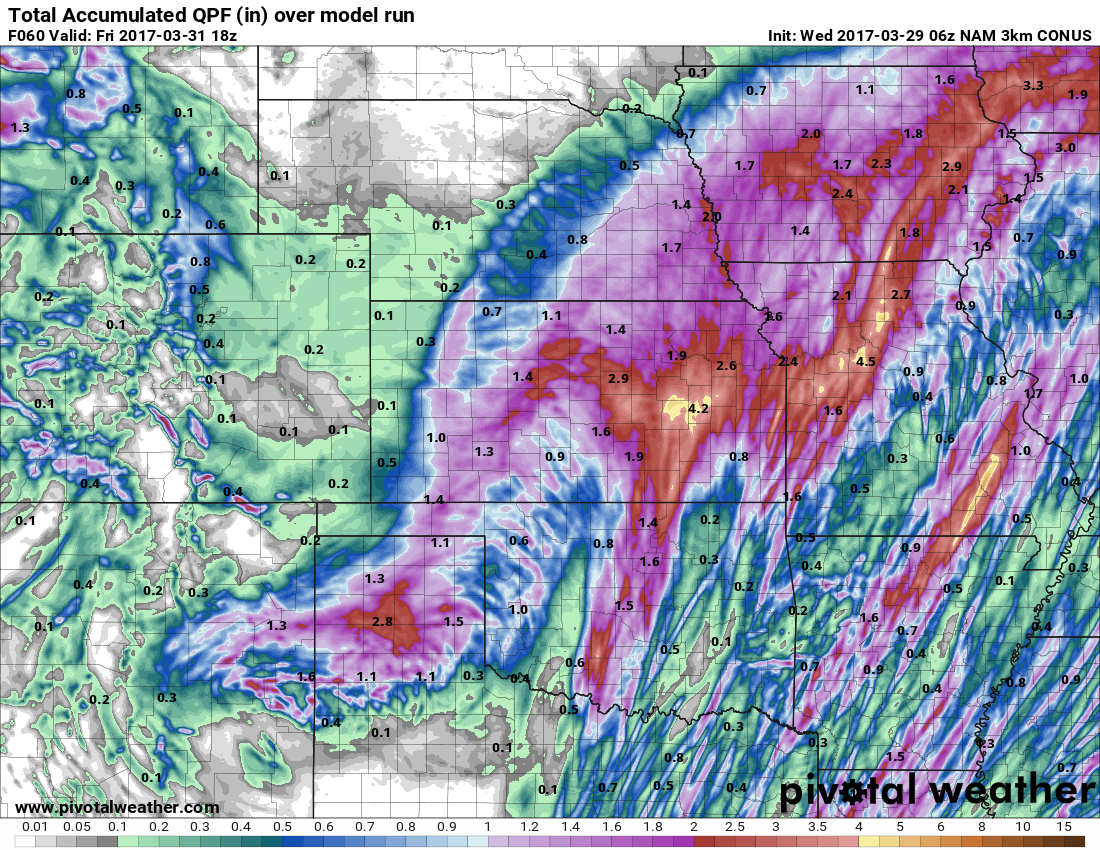
Current Radar…heavy rainfall working into Missouri and Iowa today.
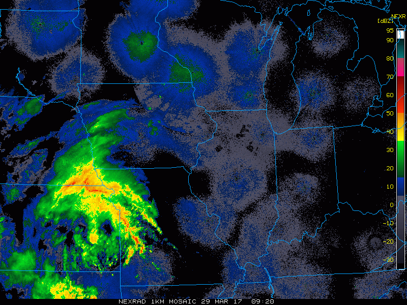
Showers and thunderstorms works north and east along the low pressure today across eastern Nebraska, eastern Kansas to Iowa and Missouri. We have a growing concern for strong storms across eastern Kansas and Missouri today as well as clusters to even discrete supercells will be possible.
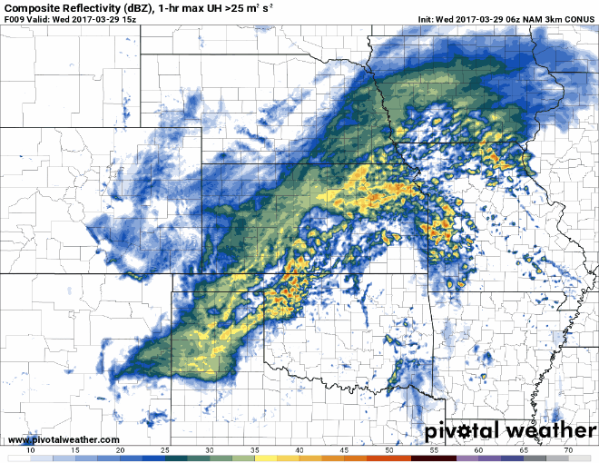
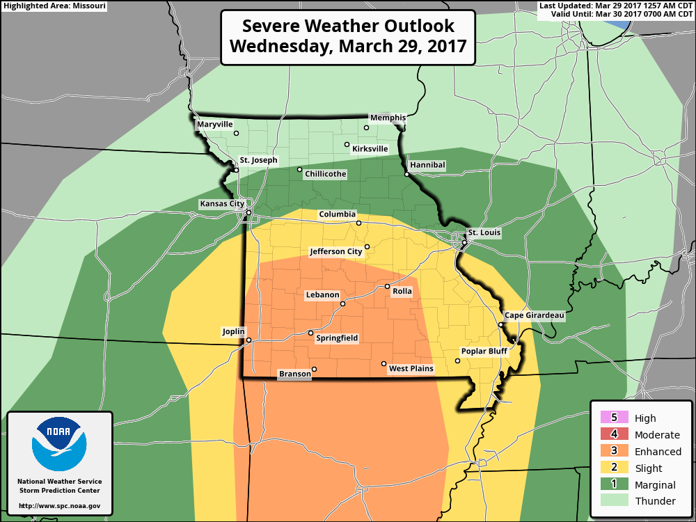
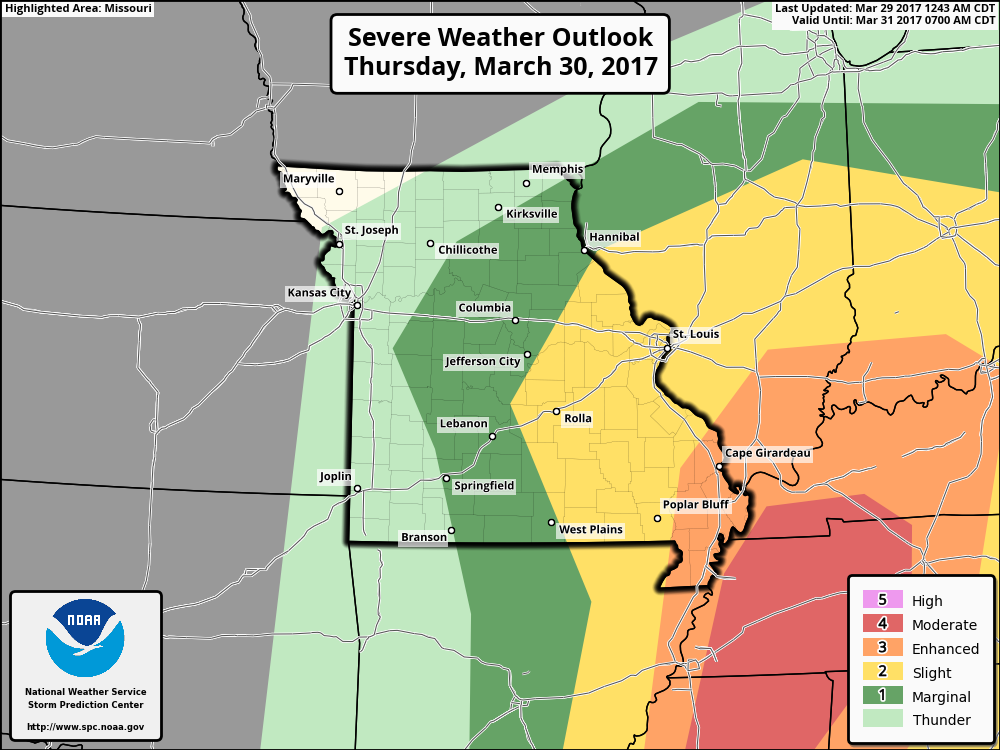
Risk area for strong to severe storms today mainly focused across eastern Kansas and Missouri with damaging winds, isolated large hail even tornadoes cannot be ruled out…especially across Missouri. We highly encourage folks in this area to stay weather aware and heed all severe warnings.
Showers and storms push further east on Thursday mainly focused across Iowa and Missouri with some lingering showers possible early Friday morning before pushing east into the Midwest. Coverage is expected to be ~50%, so fairly scattered in nature. Nebraska and Kansas dry out Thursday as well.
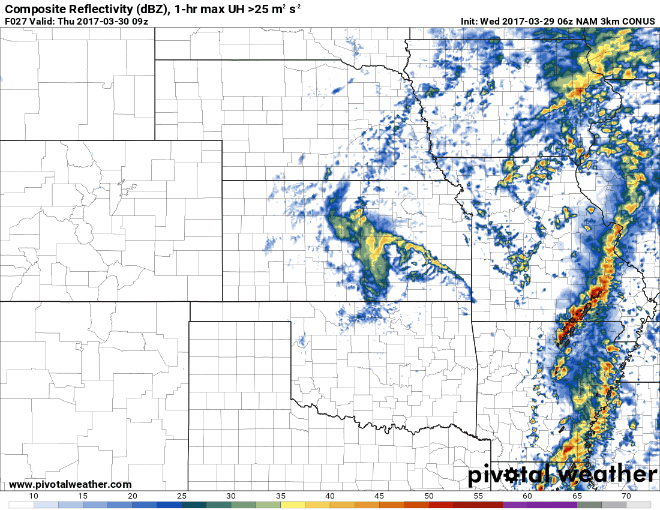
Risk area for strong to severe storms Thursday mainly across the eastern half of Missouri as these storms shift off to the Midwest and Tennessee Valley. The main threats being damaging winds and isolated large hail.
Total rainfall through Friday…we see a large swath of 1-3″+ from Kansas to eastern Nebraska to Iowa and Missouri…meanwhile the western half of Nebraska stays mostly dry.
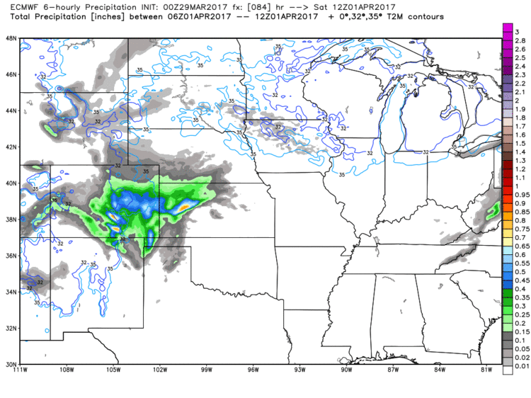
Our next system is on its heals coming to western Zone 8 locations Saturday morning and moving east into Iowa and Missouri on Sunday with a few rumbles of thunder possible. The next system follows right behind it especially across Missouri that will keep things wet into early next week. Folks across Nebraska and Kansas have a drier second half of the weekend.
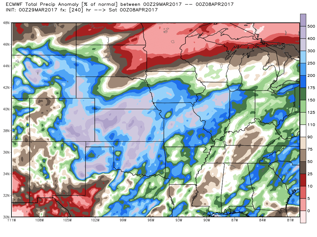
When looking at precipitation from normal over the next 10 days, we see how active we really are with basically the entire zone at 175-300% (even 400%) above the normal. This is good news especially across the hard red winter wheat crop areas that have been very dry this year so far.
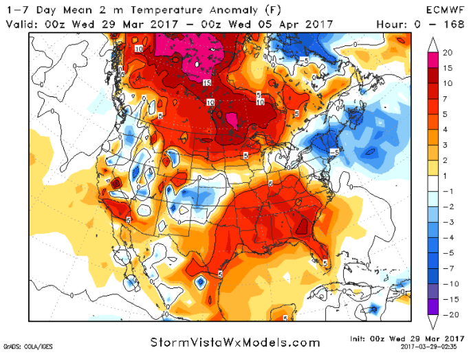
Our Zone experiences many extreme temperature swings over the next week which we cover in full detail in the video. Overall, the western half of Zone 8 stays normal to cooler than normal, Iowa is fairly normal as well…meanwhile Missouri experiences largely above normal temperatures over the next week.
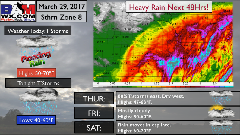
Northern Zone 8 Quickcast…heavy rain possible over the next 2 days!

Southern Zone 8 Quickcast…watching for heavy rains over the next 48 hours!
Confidence and Risk:
- High confidence showers and storms continue east today especially across eastern Kansas/Nebraska, Iowa into Missouri.
- Average to above average confidence of strong storms across eastern Kansas into Missouri.
- Average risk for the threat for tornadoes as well today…especially across Missouri.
- Above average confidence showers and storms shift east across Iowa and Missouri on Thursday while NE and KS dry out.
- Increasing confidence of additional showers and rumbles of thunder this weekend as our next disturbance moves east of the Rockies into the Zone.
Today’s Video (7 min):