Good afternoon! Here is the latest winter threat blog. These will be issued for free this entire winter. These are just broad discussions of the winter pattern and the main drivers behind it. For a daily detailed analysis, inquire at [email protected]
This blog will discuss the implications that the Pacific jet stream can have on the weather pattern heading into winter. Even with other favorable factors for colder weather, a stronger than normal jet stream can throw a major wrench in the forecast as it can carry mild Pacific air into the U.S. and prevent the extent and staying power of arctic air.
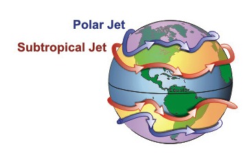
First off – what is a jet stream? Jet streams are narrow bands of fast moving air in the upper levels of our atmosphere that follow the boundaries between warm and cold air. Jet streams are located roughly 7 miles above Earth’s surface – the level where jets fly, hence the name. There are two distinct jet streams that impact the United States. The biggest one that impacts the U.S. is the polar front jet stream which usually resides near 50/60º North and South latitudes, and another jet stream near 30º N/S latitude called the subtropical jet stream. These are part of the general circulation features that impact the weather around the world, and we see the average position of these jet streams shift further north in the summer and southward into winter in both the North and South Hemisphere. Jet streams are stronger in the winter due to stronger temperature gradients, and weaken in the summer as temperature gradients are weaker. Position of jet streams play a critical role in the weather as they steer storm systems across the mid-latitudes (called mid-latitude cyclones). These are the systems that bring anything from your severe weather events and winter storms across the U.S.
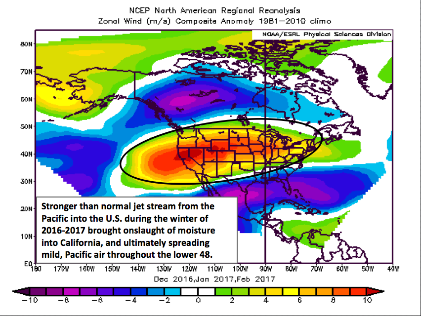
Now that we have some background on what jet streams are, let’s delve more into the implications that jet streams can play in our weather especially heading into winter. We can’t talk about last winter without discussing the Pacific jet stream which played a *MAJOR* role in last winter’s outcome! An interesting sea surface temperature configuration developed in the late fall and lasting through the winter where the north Pacific Ocean became much cooler than normal due to a stronger than expected build-up of arctic air over Siberia in November. Meanwhile, the waters in the central Pacific were much warmer than normal. This strong temperature gradient is what created the strong Pacific jet stream “firehose”, bringing an endless supply of storms into the west coast (eroding the California drought) but also flooding the lower 48 with this mild, Pacific air and preventing any staying power for cold air across the country.

When you look at the upper level winds last winter compared to “normal”, we find that the jet stream winds were much stronger than normal from the Pacific straight eastward across the United States (indicated by the oranges and reds).
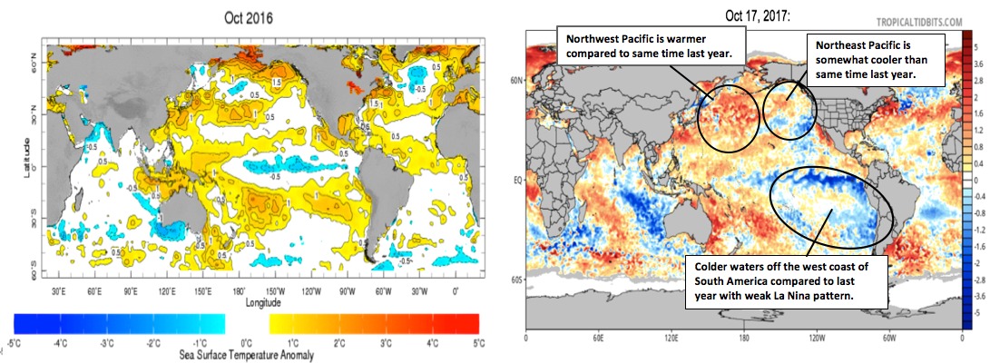
What about this winter? Do we face the potential of another strong Pacific jet stream to wreak havoc on the forecast? First off, let’s do some comparing of sea surface temperatures in the Pacific from October 2016 to today’s date. We notice an overall very similar sea surface temperature pattern, but some differences noted. The biggest difference this year compared to last year is the expansion of colder water off the west coast of South America with a weak La Nina pattern developing. ***Important to note here that the temperature gradient was not very pronounced at this point last year in the Pacific Ocean – as the North Pacific was still warmer than normal. It will be very important to watch how these sea surface temperatures trend heading through November.***
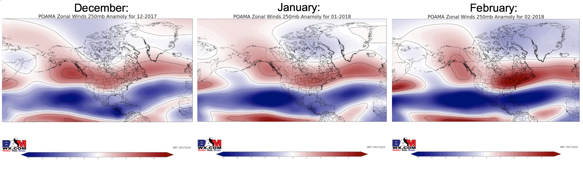
Here are some forecasts of the upper-level wind anomalies during December-February of this upcoming winter to get a measure of the jet stream winds compared to normal. The area in red on these maps indicates where the jet stream will be stronger than normal. This has a very La Nina-like look with the active jet stream carrying plenty of moisture from the Pacific Northwest down into the Ohio Valley and Northeast.
It should be noted that a stronger than normal jet stream alone does NOT mean we will see a warmer pattern. The configuration of the jet stream is key and upper-level blocking can help create stronger dips in the jet stream across the U.S. leading to colder risks. The negative QBO (which has been discussed in previous blogs; see here: https://bamwx.com/2017/10/02/check-up-on-latest-thoughts-into-the-upcoming-winter-n/) may work in winter-lover’s favor allow for increased shots of cold air to spread into the U.S.
The main take-away here is that we need to monitor how the sea-surface temperatures evolve over the next month or two to gauge how the Pacific jet will evolve this winter. We know this feature played a major role in our very warm winter outcome last year. The risks are still there that a strong Pacific jet could once again wreak havoc on the forecast. We hope you found this blog interesting and useful. Have a great day! -Nathan