An atmospheric river is coming to the Western US.
By Bret Walts
The west coast of the United States has very unique weather patterns – often dealing with a wide range of patterns from excessive moisture aided by mountains to persistent drought. Much of this variation is related to the placement and intensity of the Pacific Jet stream.
Often times, we hear the influence of the Pacific Jet referred to as an Atmospheric River when it extends all the way to the west coast. These “rivers” are generally only a few hundred miles in width and occur when jet stream winds and water vapor transport overlaps. They can bring excessive waves of rain and snow to the west coast of the US.

During abnormally strong atmospheric river events, the onslaught of storm systems spanning from Hawaii/Central Pacific to the West Coast are often referred to as the “Pineapple Express”. A Pineapple Express is expected to ramp up over the next 7 – 10 days thanks to an intensification of the Pacific Jet stream related to a strong El Niño. Note in the loop below the persistent stream of moisture from Hawaii to the Pacific Northwest:

As wind and moisture converge against terrain on the west coast, rain and snow will be amplified. The latest European model indicates the potential for 6 – 12″+ of precipitation over the next 7 – 10 days and some mountainous areas receiving several FEET of snow:
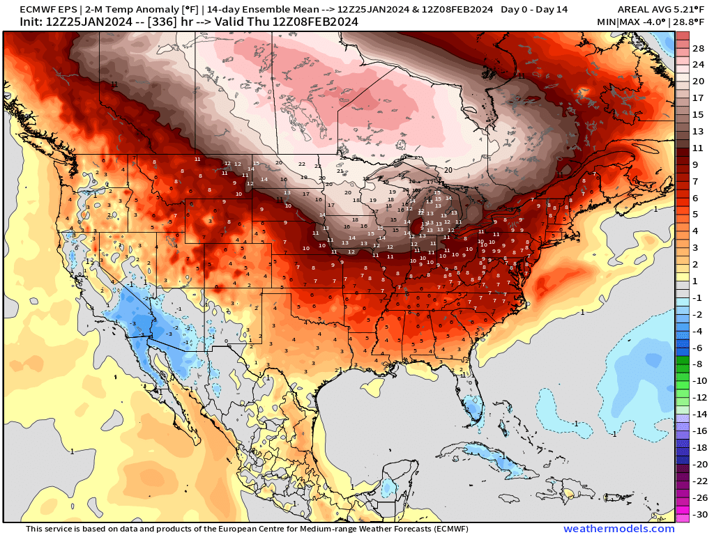
As we mentioned above – this extreme event is directly related to the powerful Pacific Jet stream – which is more common in strong El Niño years. 2023 – 24 has already risen to the 6th strongest El Niño of all time and the second strongest since 2000. This abnormally strong jet stream will also quickly bring a return to much warmer than normal temperatures for much of the United States as it pumps in mild Pacific air rather than the colder Canadian/Arctic that had settled in during mid-January (temperature anomalies the next 14 days below):