BAMWX Logo
  • Log In
    • Clarity by BAM Log in
    • Commodity | Forensic Log In
  • Platform: Clarity
    • Clarity Overview
    • Clarity Features
    • Clarity Tutorials
  • Industries
    • Ag Weather Forecasts
    • Snow Removal
    • Operations
    • School-University Solutions
    • Outdoor Event Solutions
    • Government
    • Personal Use
    • Commodity Report Solutions
    • BAM Weather API
  • Learn
    • About BAMWX
      • Join Our Team
      • Meet the Staff
      • Press Releases
      • BAMWX Shop
      • Our Story
    • Resources
      • BAM Weather Blog
        • Success Stories
        • Weather Education
        • Weather Headlines
        • Policy Highlights
        • Use Cases
        • Industry News
    • Weather Tools
      • Wet Bulb Globe Temperature Calculator
      • Heat Index Calculator
      • Growing Degree Day Calculator
    • BAM Newsletter
  • Contact Us
    • Sales Inquiries
    • Customer Service
    • Media Inquiries
Menu
  • Log In
    • Clarity by BAM Log in
    • Commodity | Forensic Log In
  • Platform: Clarity
    • Clarity Overview
    • Clarity Features
    • Clarity Tutorials
  • Industries
    • Ag Weather Forecasts
    • Snow Removal
    • Operations
    • School-University Solutions
    • Outdoor Event Solutions
    • Government
    • Personal Use
    • Commodity Report Solutions
    • BAM Weather API
  • Learn
    • About BAMWX
      • Join Our Team
      • Meet the Staff
      • Press Releases
      • BAMWX Shop
      • Our Story
    • Resources
      • BAM Weather Blog
        • Success Stories
        • Weather Education
        • Weather Headlines
        • Policy Highlights
        • Use Cases
        • Industry News
    • Weather Tools
      • Wet Bulb Globe Temperature Calculator
      • Heat Index Calculator
      • Growing Degree Day Calculator
    • BAM Newsletter
  • Contact Us
    • Sales Inquiries
    • Customer Service
    • Media Inquiries
Get Instant Access
  • Log In
    • Clarity by BAM Log in
    • Commodity | Forensic Log In
  • Platform: Clarity
    • Clarity Overview
    • Clarity Features
    • Clarity Tutorials
  • Industries
    • Ag Weather Forecasts
    • Snow Removal
    • Operations
    • School-University Solutions
    • Outdoor Event Solutions
    • Government
    • Personal Use
    • Commodity Report Solutions
    • BAM Weather API
  • Learn
    • About BAMWX
      • Join Our Team
      • Meet the Staff
      • Press Releases
      • BAMWX Shop
      • Our Story
    • Resources
      • BAM Weather Blog
        • Success Stories
        • Weather Education
        • Weather Headlines
        • Policy Highlights
        • Use Cases
        • Industry News
    • Weather Tools
      • Wet Bulb Globe Temperature Calculator
      • Heat Index Calculator
      • Growing Degree Day Calculator
    • BAM Newsletter
  • Contact Us
    • Sales Inquiries
    • Customer Service
    • Media Inquiries
Menu
  • Log In
    • Clarity by BAM Log in
    • Commodity | Forensic Log In
  • Platform: Clarity
    • Clarity Overview
    • Clarity Features
    • Clarity Tutorials
  • Industries
    • Ag Weather Forecasts
    • Snow Removal
    • Operations
    • School-University Solutions
    • Outdoor Event Solutions
    • Government
    • Personal Use
    • Commodity Report Solutions
    • BAM Weather API
  • Learn
    • About BAMWX
      • Join Our Team
      • Meet the Staff
      • Press Releases
      • BAMWX Shop
      • Our Story
    • Resources
      • BAM Weather Blog
        • Success Stories
        • Weather Education
        • Weather Headlines
        • Policy Highlights
        • Use Cases
        • Industry News
    • Weather Tools
      • Wet Bulb Globe Temperature Calculator
      • Heat Index Calculator
      • Growing Degree Day Calculator
    • BAM Newsletter
  • Contact Us
    • Sales Inquiries
    • Customer Service
    • Media Inquiries
BAMTornado
Get Instant Access

Author: Chief Meteorologist Michael Clark

  • Home
  • Chief Meteorologist Michael Clark
  • Page 491
28
Feb
By Chief Meteorologist Michael Clark

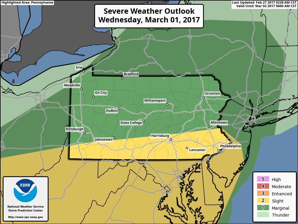
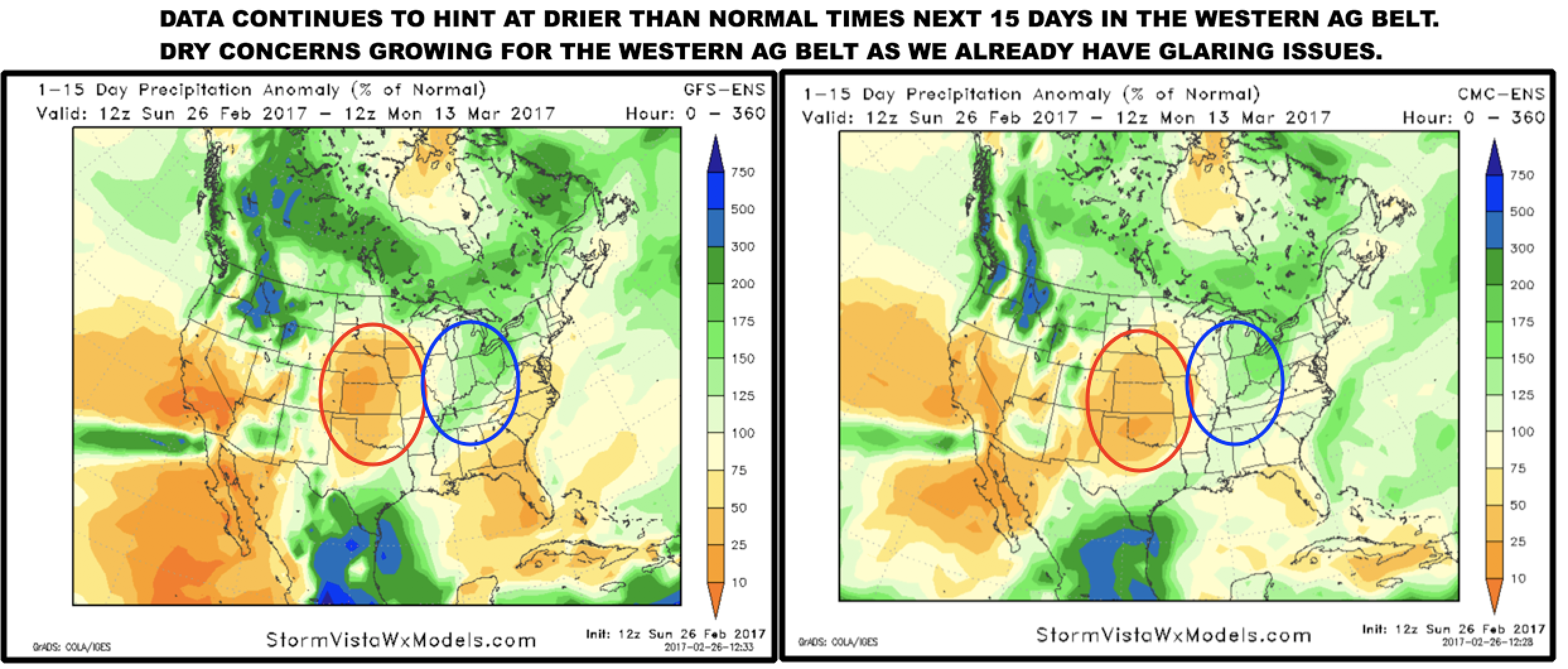
#Ag #AGwx #Harvest17 South America Long Range: Analyzing March and Beyond. E.

Good morning and thanks for checking out this South America update! Let's take a look at how the region has faired over the last week with respect to rainfall. Variable precipitation occurred across Argentina and RGS Brazil while Uruguay, southern Paraguay, and central Brazil were rather dry. Northern Brazil was…
Read More
2.28.17 #Energy and #Natgas Report. E.
28
Feb
By Chief Meteorologist Michael Clark

2.28.17 #Energy and #Natgas Report. E.

Good morning. The step down demand process to Spring looks to continue over the coming weeks as warmer temperatures appear likely through much of March. An active storm track through the Midwest in week 1 will pump even more warmth into the eastern U.S. and that is shown well in…
Read More
#OHwx #PAwx #NYwx #NJwx #MAwx #CTwx Severe Weather Expected Today West, Wednesday East. Details Here.
28
Feb
By Chief Meteorologist Michael Clark

#OHwx #PAwx #NYwx #NJwx #MAwx #CTwx Severe Weather Expected Today West, Wednesday East. Details Here.

Good morning. Much of the region is quiet this morning, but a warm front is moving through Ohio with a few showers. There's also a few light showers across CT and MA. Some hill towns of MA are near freezing so watch out for a few slick spots early this…
Read More
#OHwx #PAwx #NYwx #NJwx #CTwx #MAwx Severe Weather Tuesday-Wednesday? Details Here. E.
27
Feb
By Chief Meteorologist Michael Clark

#OHwx #PAwx #NYwx #NJwx #CTwx #MAwx Severe Weather Tuesday-Wednesday? Details Here. E.

Good afternoon! We continue to monitor a strong warm front that will move through the region Tuesday. This will spark some severe weather Tuesday afternoon and evening across Ohio. Here's the updated SPC outlook for Tuesday. Here's an updated forecast radar Tuesday. Storms will be strongest across Ohio where there…
Read More
2.27.17 #Energy and #Natgas Report. E.
27
Feb
By Chief Meteorologist Michael Clark

2.27.17 #Energy and #Natgas Report. E.

Good morning. The pattern over the next few weeks remains warm overall with some brief stints of cold behind storm systems. This is being driven by both the Pacific and Atlantic atmospheric patterns. We do continue to see a strong storm system on the 1st and 2nd which will pump…
Read More
#ohwx #pawx #nywx #njwx #ctwx #mawx Severe Weather Midweek, Snow Late Week?
27
Feb
By Chief Meteorologist Michael Clark

#ohwx #pawx #nywx #njwx #ctwx #mawx Severe Weather Midweek, Snow Late Week?

Good morning. Much of the region is quiet this morning. Some light rain and snow showers are falling across Ohio this morning with temperatures mainly above freezing so no accumulations are expected.  Here’s the radar as of 5:30 AM. Those will move east as light rain showers through southern PA…
Read More
Sunday long-range #AGwx #Plant17 #Energy analysis. Volatile pattern to continue. M.
26
Feb
By Chief Meteorologist Michael Clark

Sunday long-range #AGwx #Plant17 #Energy analysis. Volatile pattern to continue. M.

Sunday long-range #AGwx #Plant17 #Energy analysis. Volatile pattern to continue. M. Active pattern with wild swings looks to continue. I'll give you a run down of what we will be discussing this week. First things first and that's a possible multi-day severe weather outbreak across the eastern and southern Ag…
Read More
#PAwx #NYwx #NJwx #CTwx #MAwx Severe Weather Possible Across the Interior Today!
25
Feb
By Chief Meteorologist Michael Clark

#PAwx #NYwx #NJwx #CTwx #MAwx Severe Weather Possible Across the Interior Today!

Good morning. Thoughts from yesterday remain largely unchanged, and as discussed last evening, the threat for severe thunderstorms has increased and expanding northward and eastward according to the SPC. Here's the latest outlook. Notice much of eastern PA, New York, and New Jersey are under a "slight risk" for a…
Read More
#OHwx #WVwx #PAwx #NYwx #NJwx 2.24 PM NE Update: Gusty Storms Late Tonight into Saturday
24
Feb
By Chief Meteorologist Michael Clark

#OHwx #WVwx #PAwx #NYwx #NJwx 2.24 PM NE Update: Gusty Storms Late Tonight into Saturday

Good afternoon! Quick update on the strong thunderstorms expected across the region late tonight through Saturday. The latest SPC outlooks match my thoughts fairly closely for tonight and tomorrow, painting a slight risk almost to the PA border tonight and a marginal risk across PA and NJ tomorrow. As discussed in…
Read More
2.24.17 #Energy and #Natgas Notes: Analyzing the 16-30 Day Period. E.
24
Feb
By Chief Meteorologist Michael Clark

2.24.17 #Energy and #Natgas Notes: Analyzing the 16-30 Day Period. E.

Good morning. In today's edition of the energy notes, we take a closer look at the 3 and 4 week time frame. At this time, this period appears quite volatile with cold risks in week 3 and perhaps some significant warm risks in week 4. Right now, data, model analogs,…
Read More

Posts pagination

Prev 1 … 490 491 492 … 501 Next

BAM Weather: 

Making weather decisions simple for everyone with the best forecasts. Period.

Facebook Youtube

Company

Our Story

Contact BAMWX

Press Releases/News

Terms and Conditions

Privacy Policy

General Service Agreement

Platforms

Clarity Weather

BAM Commodity Reports

Sectors

Agriculture

Snow Removal

Operational

Schools/Universities

Outdoor Events

Government

Engagement

Media Inquiries

Sponsorships

Careers

Logos/Branding

Speaking Engagements

Press Releases

Resources

Clarity Use Cases

Customer Stories

Policy Highlights

Industry News

How Weather Works

Weather Headlines

Competitor Comparisons

Clarity vs. DTN & Perry Weather