Wednesday #AGwx Update: A Look at the August Forecast. E. Slides: Today's Video (11 minutes): https://www.youtube.com/watch?v=6iUVoQ2HJOA&feature=youtu.be&hd=1
*SPECIAL FLASH FLOODING UPDATE* #ILWX #INWX #OHWX Synopsis: Today's update focuses on the very heavy rainfall and strong storm threat across central Indiana into central Ohio today. If you have any questions, please do not hesitate to reach out! Current Radar Simulated radar guidance as these very heavy storms push…
#MNwx #WIwx #NDwx #SDwx: Severe t'storm risk today, briefly cooler and drier air builds in mid to late week. N. Synopsis: Active weather for today into Wednesday as an area of low pressure tracks across the region. High pressure will build in for the second half of the week bringing drier…
Tuesday #AGwx Report: Breaking Down Latest Data Through July. E. Slides: Today's Video ( 11 minutes): https://www.youtube.com/watch?v=9AmokABAUgw&feature=youtu.be&hd=1
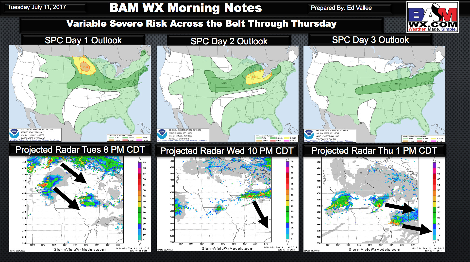
Zone 3/4 #ILwx #KYwx: Active Next Few Days, Cooler This Weekend. E. Key Points: July 11, 2017 Synopsis: Good Tuesday morning! We are tracking some thunderstorms moving through central Illinois this morning bringing heavy rain and some wind and hail as well. These will persist through today with periodic storms…
#NEwx #KSwx #MOwx #IAwx #MNwx #WIwx #NDwx #SDwx Update on storm chances over the next 48 hours. N. Good afternoon! Current radar remains quiet, with just a few showers showing up over northern Nebraska. The radar will become more active as we head into this evening and overnight. Below is…
Video from this morning is what I will go with for this afternoon for now. I debated doing a new video but with this mornings runs I feel like all it will do is add confusion as models are just nuts right now. If you have any questions about anything…
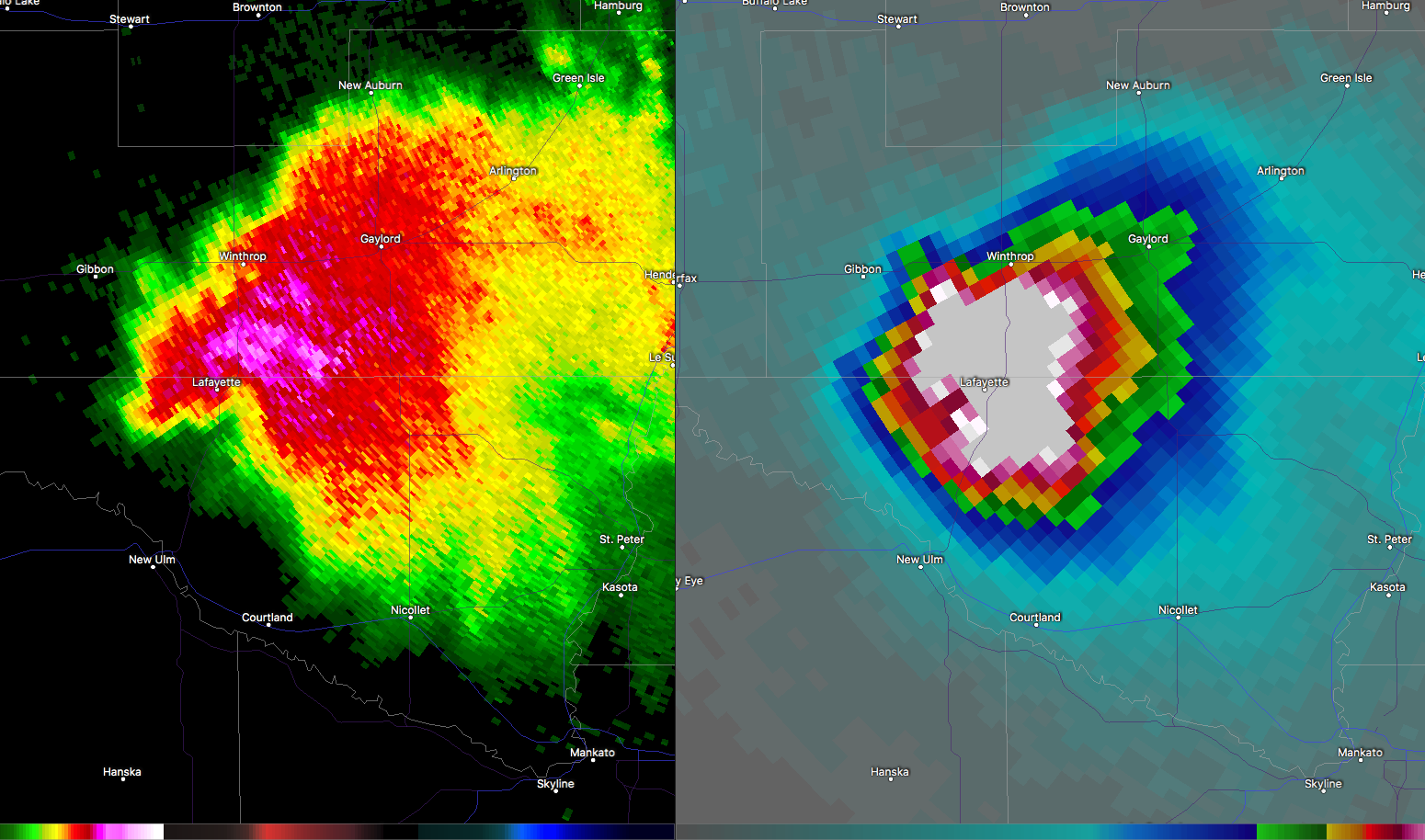
*SPECIAL UPDATE* SIGNIFICANT CROP DAMAGE COMING IN THIS MORNING FROM MCS THAT WENT THROUGH OVERNIGHT. GETTING SEVERAL TEXTS AND REPORTS FROM CLIENTS FROM MN TO IN ON SHREDDED CORN CROP FROM LARGE HAIL LAST NIGHT. I HAVE CIRCLED WHERE THIS DAMAGE HAS LIKLEY TAKEN PLACE BASED ON RADAR ANALYSIS AND…
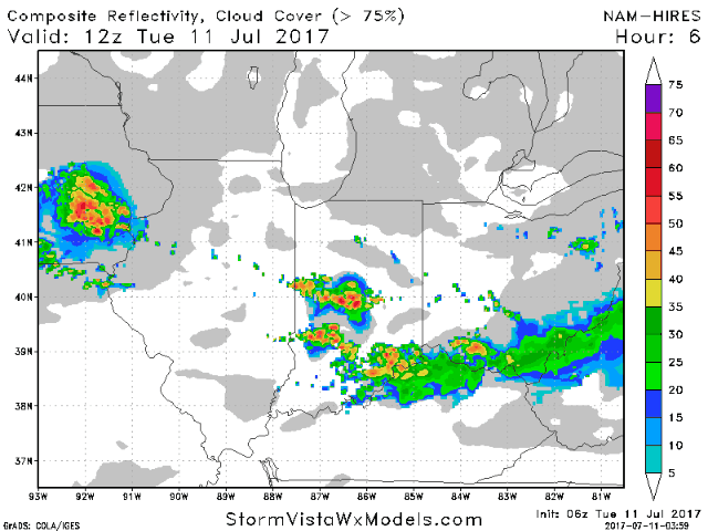
Synopsis: It will be rather active into mid-week with rounds of showers and thunderstorms possible. More details are covered in the video at the end of the post. Current Radar: Radar loop this morning shows a complex of storms pushing southeast of Wisconsin which led to the severe weather last…