This week, the Pacific Northwest was struck by one of the most powerful atmospheric rivers on record, which also classified as a bomb cyclone—a type of mid-latitude storm that undergoes rapid intensification. This system experienced a dramatic drop in pressure, from 1000mb to 942mb in just 24 hours, far surpassing the minimum 24mb pressure drop required to qualify as a bomb cyclone. The storm’s central pressure of 942mb aligns with the pressure typically found in a Category 4 hurricane, a rare and intense weather event for this region.
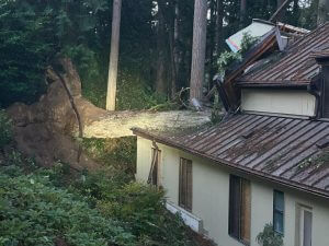
The destruction caused by this potent cyclone was widespread, particularly in Washington state. Over half a million residents were left without power early Wednesday morning, and widespread road closures occurred due to fallen trees and debris. Tragically, at least two fatalities were reported, both caused by falling trees.
These wind speeds were equivalent to those of a Category 1 hurricane, particularly affecting Washington and Oregon. Here’s a look at some of the strongest wind gusts:

- A buoy off Vancouver Island: 101 MPH
- Blue Gulch, OR: 85 MPH
- Pendleton, OR: 85 MPH
- Sunrise (Rainier, WA): 77 MPH
- Enumclaw, WA: 74 MPH
While the wind was intense in these states, northern California was hit harder by heavy precipitation associated with the system. Numerous landslides were reported, blocking several roads. The storm also brought heavy snowfall at higher elevations, contributing to dangerous conditions in mountain areas.
The combination of intense winds, heavy rain, and significant snowfall caused widespread disruption, demonstrating the formidable power of this bomb cyclone as it impacted the Pacific Northwest.
Heavy rain and snow continues to feed into Northern California and an additional 5″-7″ of rainfall is expected in the lower elevation areas. Thankfully, looking at the outlook ahead, below normal precipitation is favored in this region as the month of December rolls around.
You can get long range outlooks and a whole lot more with our Clarity weather platform: claritywx.com/sign-up!
|
|
|


