
Key Points – Friday, February 10, 2017
Synopsis: Good Friday morning! Wow, does it not seem like these days and weeks are already flying by? If you’re keeping track, meteorological spring is actually only 18 days away for you spring lovers out there. Today’s video we focus on the forecast this weekend into next week. We have some concerns for some fog developing over the current snowpack tonight into Saturday morning as temps warm throughout the day today. Temperatures will be fairly mild today through the weekend as well, winds will be quite gusty Friday and Sunday as well with winds out of the south to southwest gusting at 30-35mph today, veering more towards the NW on Sunday as a front pushes through…winds gusting at 25-30 mph. Expecting pesky showers to move from west to east Saturday night, not expecting these to bring much in the way of rainfall, totals right now hovering between 0.1-0.25″ across the Midwest. A quiet weather pattern settles in next week, a lot of dry time with sunshine expected throughout the Ohio Valley…we are, however, keeping an eye a possible rain/snow mix mainly across Zones 1/2 Wednesday into Thursday morning, but confidence right now is low. We briefly touch on the long-range towards the end of today’s video, discussing the continued warmth over the next 2 weeks…the latest European Weeklies also suggest a “stormy” pattern potentially setting up across portions of the Ohio Valley into the Deep South…so make sure you are staying tuned to BAMwx.com going forward into spring!
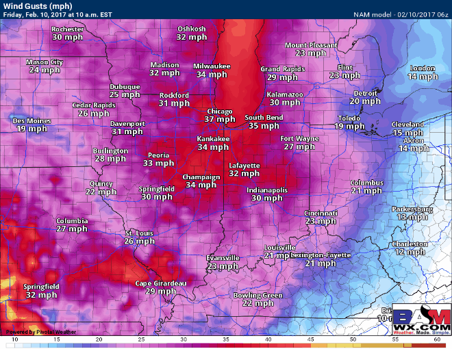
Expecting partly sunny skies at times across the Midwest today with temps increasing into the afternoon, winds pick up today as well out of the south/southwest gusting upwards of 35mph! A little lull in winds on Saturday, but winds pick up more out of the northwest into Sunday as a front pushes through, gusting at ~25mph.
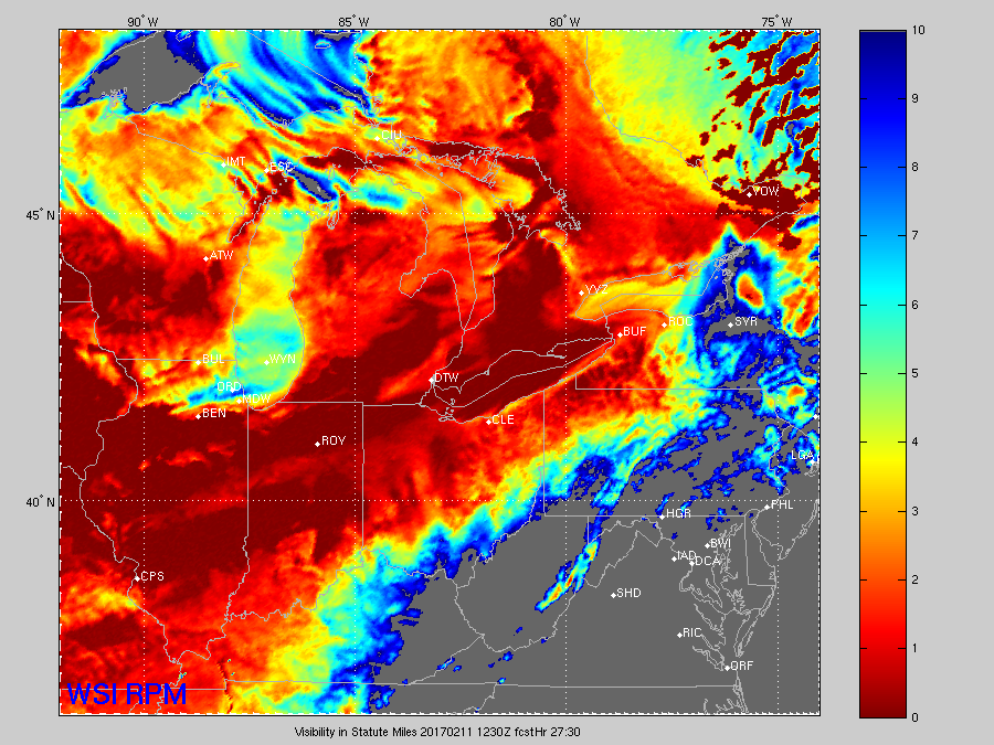
I have some concern for fog developing tonight into Saturday morning, as the warmer air and southerly winds moving into the Midwest today crosses over the top of our current snowpack…which is a good recipe for fog. A few slick spots are possible as well in locations that dip near freezing as discussed in the video.

The latest RPM model is picking up on some reduced visibilities into Saturday morning, indicated by the darker oranges and reds as seen below.
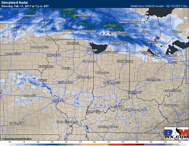
Pesky showers work in from west to east on Saturday afternoon into the overnight, this is by no means a heavy rain maker but just enough to keep things damp.
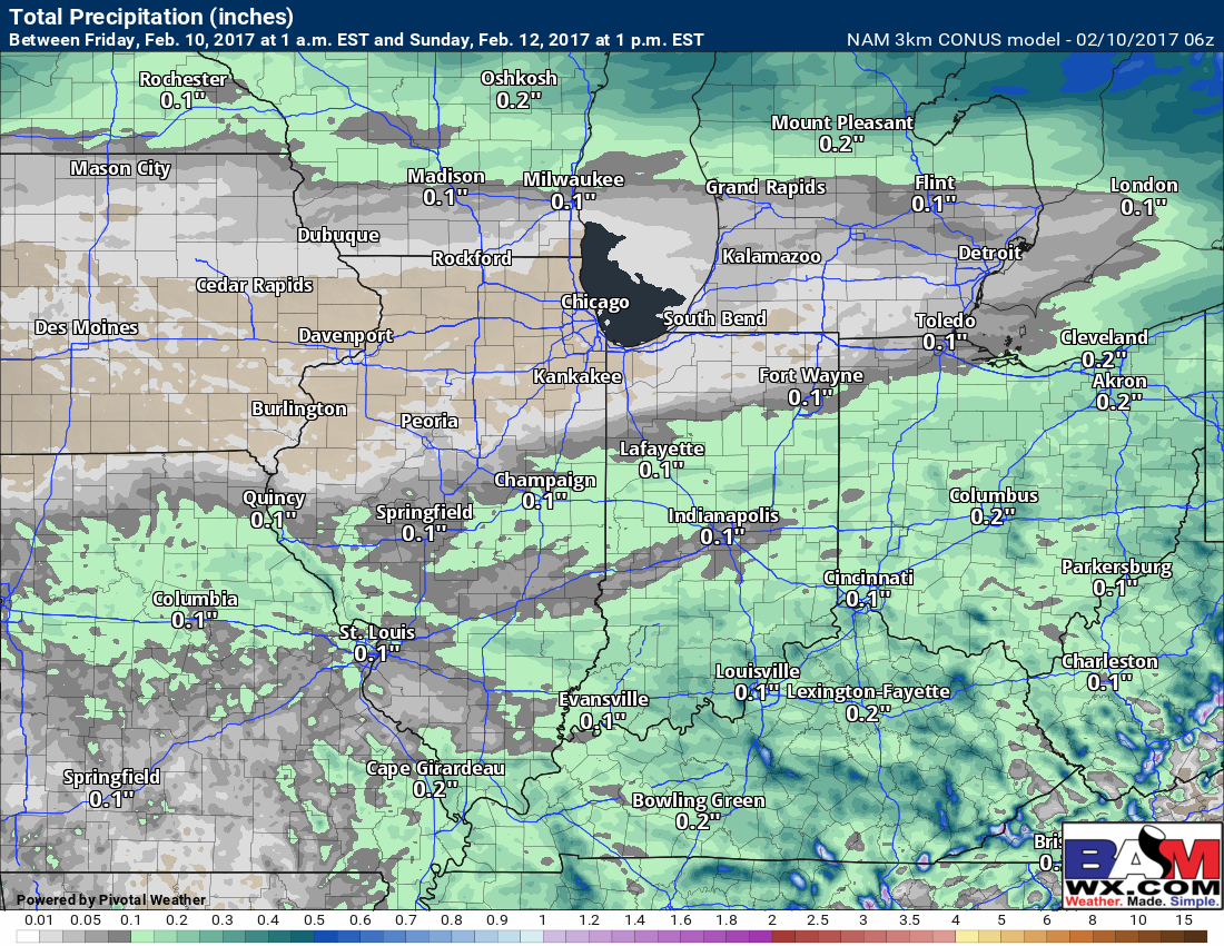
Current thoughts on accumulations are between 0.1-0.25″ (the GFS suggests maybe a few spots ~0.3″ or so) right now…data has remained consistent with this.
A quiet weather pattern settles in next week, a lot of dry time with sunshine expected throughout the Ohio Valley…we are, however, keeping an eye a possible rain/snow mix mainly across Zones 1/2 Wednesday into Thursday morning, but confidence right now is low.

We also touch on the long-range in today’s video, discussing the continued warmth over the next 2 weeks…the latest European Weeklies also suggest a “stormy” pattern potentially setting up across portions of the Ohio Valley into the Deep South. We continue to eye the end of February into March, however, for a little shift to possibly cooler…a trend we need to continue to watch.

Confidence and Risk:
- Above average confidence temperatures begin to climb today into the weekend to above normal.
- Above average confidence in a windy forecast Friday out of the S/SW up to 35 mph, and out of the NW Sunday gusting ~25mph.
- Increasing confidence of foggy conditions setting up tonight into Saturday morning as warm air moves over current snowpack…watching for a few slick spots where temps dip near freezing.
- Above average confidence of pesky rain showers moving in from west to east Saturday evening into the overnight Sunday…low accumulations expected.
- Low confidence on a rain/snow mix across Zones 1/2 mid next week…need better data at this time.
- Above average confidence we stay overall warmer than normal during the next 2 weeks…latest Euro Weeklies suggests a potentially stormy pattern setting up across portions of the Ohio Valley into the Deep South deeper into February we need to keep our eyes on.
Today’s video (5 min):