
Key Points – Wednesday, February 22, 2017
Synopsis: Good Wednesday morning, we have a packed discussion today in regards to our severe weather potential late week so we urge you to watch until the very end of the video. We discuss the dense fog still lingering across the Midwest this morning, that will eventually burn off to some sunshine later this afternoon and near-record warmth again today. Cloud cover increases on Thursday as a warm front lifts north into the Midwest, increasing showers and a few storms as well during the afternoon into the evening with higher coverage expected over Zones 3/4. The first half of Friday could see some sunshine prior to the trailing cold front that is forecasted to move west to east Friday afternoon into the evening. Much of the intensity of the severe weather potential on Friday hinges on how much instability (CAPE or sunshine) we receive during the day, if we can get decent daytime heating out ahead of the line of storms things could intensify very quickly (and vice versa is still possible as well that these storms fizzle out because of not enough energy and too much wind shear). Right now, all modes of severe weather are still on the table in this order: damaging winds, hail and isolated tornadoes along or out ahead of the cold front. As the low pressure departs the Midwest to the east, temperatures drop off the table late Friday night into Saturday morning, a few snow showers will be possible on the backside of the low pressure mainly north of I-70 as well; a coating of snow is possible at this time. Stay tuned to the forecast over the coming days for additional updates on late week into this weekend’s weather, have a great day!
Latest look at the Dense Fog Advisories across the Midwest this morning.

High temperatures today depend on how quickly the low-level cloud layer can burn off this morning…the quicker the layer burns off the more likely we see near-record breaking warmth again today. Our focus turns to the severe weather threat later this week…a warm front lifts north Thursday afternoon into the evening presenting some showers and thunderstorms (some small hail and gusty winds possible with these). Higher coverage expected over Zones 3/4.
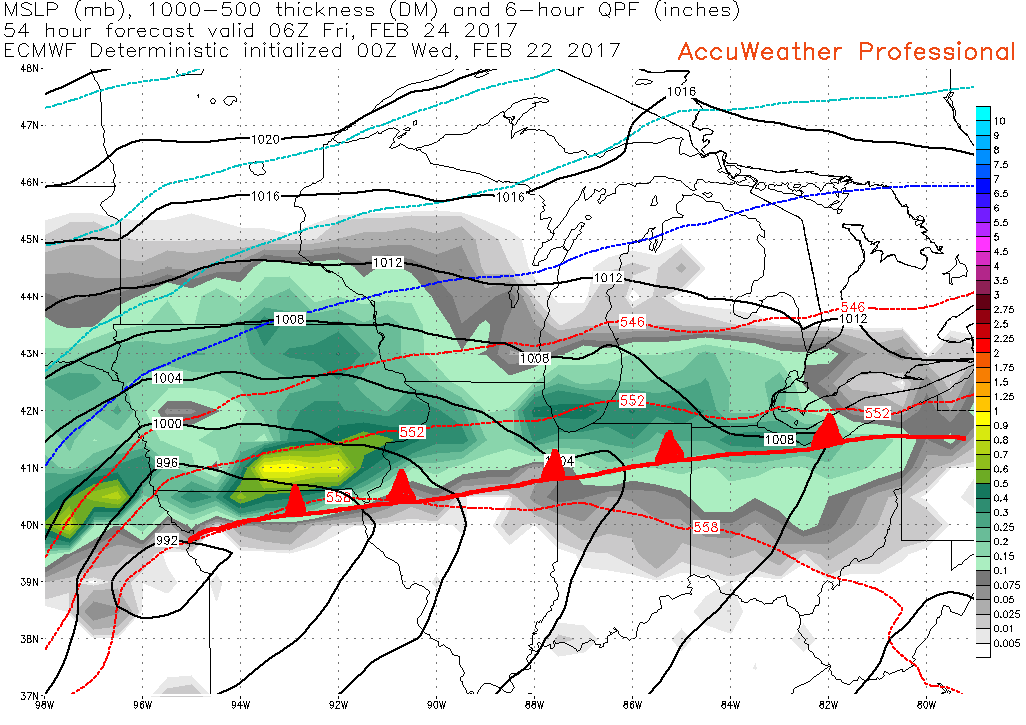
As the low pressure continues to track east on Friday, we are watching for potential “clearing” to happen (sunshine), which would add fuel to these storms and would increase intensity given how impressive the dynamics already are as we’ve been discussing. We continue to mention the threats with these storms in this order: damaging winds, hail and isolated tornadoes. Below is the timeframe (6pm-12amEST) and area we are focusing in on severe weather on Friday evening…this is subject for slight adjustments as we get closer to the event, but confidence continues to increase. This will be somewhat localized but that doesn’t take away from the higher impacts this could present being that it’s Friday.
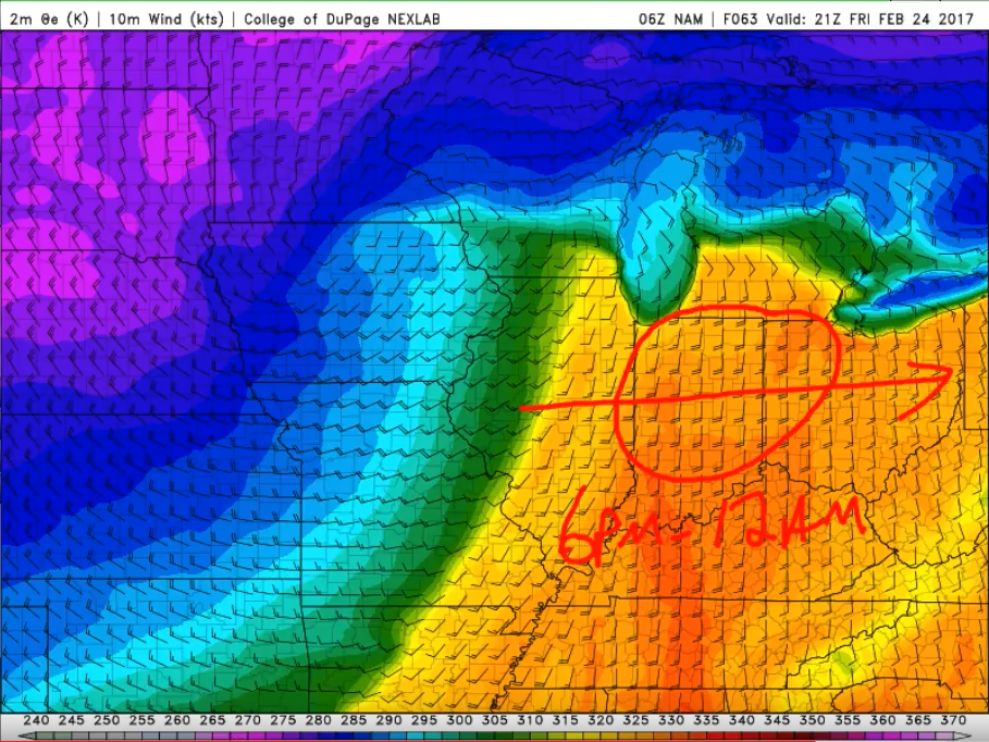
You can see, the SPC Day 3 Enhanced Risk lines up very similar to our thoughts as well on the location of severe weather.

A half-inch to an inch of rainfall totals possible out of this event, with slightly higher totals possible in the stronger thunderstorms.

Major temperature differences expected as this powerful system moves east out of the Midwest, but it will be very brief as warmer weather returns next week. A few backside snow showers possible late Friday night into Saturday morning are possible, accumulations right now look minimal but a few slick spots possible north of I-70.

We continue a very active pattern into next week so make sure to not miss an update, and please reach out to us if you have any questions!
Confidence and Risk:
- Above average confidence we see the fog stick around a little longer this morning before burning off to some sunshine and near-record warmth again today.
- Increasing confidence of showers and a few storms lifting north of the warm front on Thursday, higher coverage expected across Zones 3/4.
- Increasing confidence of strong to severe storms along or out ahead of a cold front on Friday, largely dependent on how much sunshine (instability) we receive to fuel these storms.
- Above average confidence we return to a “wintry” feel on Saturday as the powerful low pressure system departs east, a few snow showers possible on the backside as well north of I-70.
- Above average confidence we remain very active in the weather department into next week with a return to more mild weather as well.
Today’s video (6 min):