BAMWX Logo
  • Log In
    • BAM Weather Log in
    • Commodity | Forensic Log In
  • Learn
    • Press Releases
    • BAM Weather Blog
      • Success Stories
      • Weather Education
      • Weather Headlines
      • BAM Weather Use Cases
      • Industry News
  • Contact Us
    • Sales Inquiries
    • Customer Service

Becks

  • Home
  • Clients
  • Becks
  • Page 308
26
Aug
By Vince Bryan

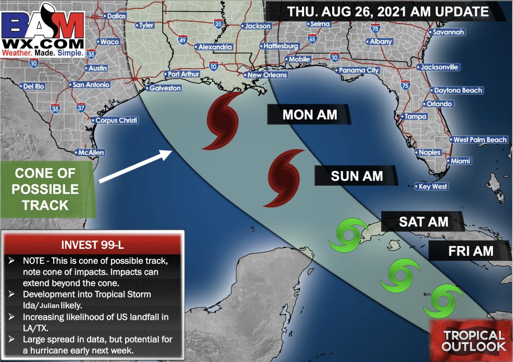
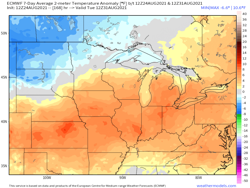
8-26-21 PM Ag Euro Weather Report: Discussing latest afternoon Euro trends.V.

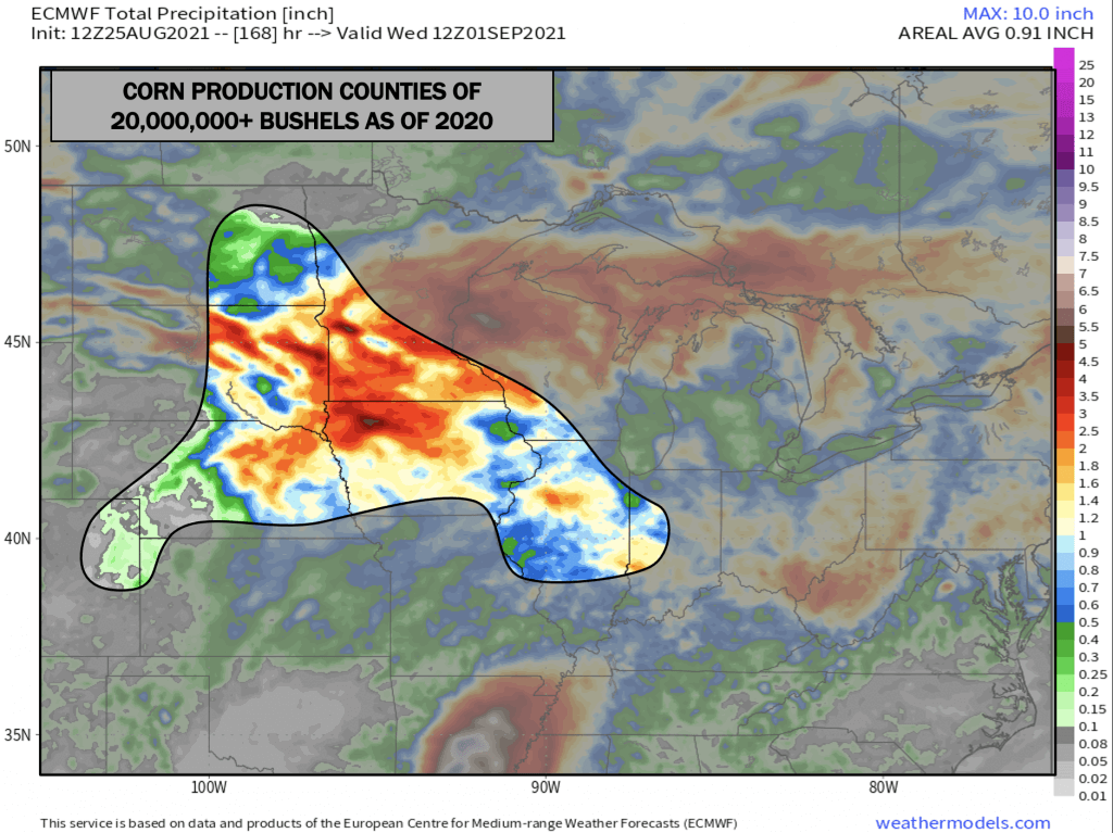
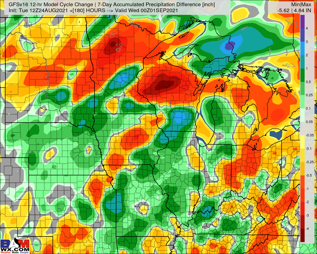
Good afternoon everyone. Below is your latest PM Ag Weather Report:  Open report here in High Resolution:  8-26-21 PM Ag-Weather Report Mid-Day Euro Changes: Slight drier trends across the E. Ag Belt on the mid-day Euro with with even wetter trends in NE Nebraska, into SE SD, S. MN and…
Read More
26
Aug
By Matt Griffin

8-26-21 PM GFS Ag Weather Report: Implications of Continued East Trends of Tropical Disturbance. MG.

Your latest PM GFS ag weather report is below, have a blessed day -Bret PDF report: 8-26-21 PM Ag-Weather Report PM GFS Changes: The GFS trended east again with the tropical system early next week which led to drier trends cross the MS and Ohio Valley regions. Drier trends also…
Read More
8-26-21 AM Ag Weather Report: Latest details on Gulf tropical system, watching risks to close week 2.B.
26
Aug
By Bret Walts

8-26-21 AM Ag Weather Report: Latest details on Gulf tropical system, watching risks to close week 2.B.

Good morning everyone. Below is your latest AM Ag Weather Report:  8-26-21 AM AG Weather Report The latest trend on our next tropical system (likely Ida) was further east again last night taking it into a more likely landfall in Louisiana or Eastern Texas. The further east this goes, the…
Read More
8-25-21 PM Euro Ag Weather Report: Active pattern continues over the next several days, latest details on tropical risks. B.
25
Aug
By Bret Walts

8-25-21 PM Euro Ag Weather Report: Active pattern continues over the next several days, latest details on tropical risks. B.

Good afternoon everyone. Below is your latest PM Ag Weather Report:  8-25-21 Euro PM Ag-Weather Report Mid-Day Euro Changes: Drier trends south in the short-term in the Ohio Valley and Iowa on the European model with heavier trends across South Dakota, Minnesota, NW Iowa and Wisconsin. Also it’s important to…
Read More
25
Aug
By Matt Griffin

8-25-21 PM GFS Ag Weather Report: Discussing wetter trends in latest run of GFS. MG.

Your latest PM GFS ag weather report is below, have a blessed day -Bret PDF report: PM Ag-Weather Report Mid-Day GFS Changes: The 12 Z GFS trended wetter for many locations across the Ag Belt with sporadic drier trends in spots. Overall, the GFS still has the bulk of the…
Read More
8-25-21 Long-range: Erratic shifts in next potential Gulf tropical cyclone & future impacts to late Aug / early Sept pattern. K.
25
Aug
By Vince Bryan

8-25-21 Long-range: Erratic shifts in next potential Gulf tropical cyclone & future impacts to late Aug / early Sept pattern. K.

*No new video update today. Big pattern influence into next week will be highly dependent how the next tropical cyclone in the Gulf develops (check slides below). Given erratic trends over the past 24 hours, we've opted not to do an updated video in hopes mid-day data will give us higher confidence. We…
Read More
8-25-21 AM Ag Weather Report: Big shifts in tropical system’s track overnight. Final track has major implications on pattern into next week. B.
25
Aug
By Bret Walts

8-25-21 AM Ag Weather Report: Big shifts in tropical system’s track overnight. Final track has major implications on pattern into next week. B.

Good morning everyone, below is your latest AM Ag Weather Report:  8-25-21 AM AG Weather Report Overall, temperatures look to remain warmer than normal across the Eastern Ag Belt and into the Central Plains for week 1. Again, this may be one of the warmest stretches of the summer for…
Read More
8-24-21 PM Euro Ag Weather Report: Wetter trends on mid-day Euro, but no changes to our thoughts. B.
24
Aug
By Bret Walts

8-24-21 PM Euro Ag Weather Report: Wetter trends on mid-day Euro, but no changes to our thoughts. B.

Good afternoon everyone. Below is your latest PM Euro Ag Weather Report:  8-24-21 PM Ag-Weather Report Mid-Day Euro Changes: The Euro trended back south with some of the heavier rain on this run in Iowa and expanded moisture in the Ohio Valley, Nebraska and Kansas as well for overall wetter…
Read More
8-24-21 PM GFS Ag Weather Report: Upper Midwest rains remained on-tap, remaining skeptical of east Ag Belt rains. K.
24
Aug
By Vince Bryan

8-24-21 PM GFS Ag Weather Report: Upper Midwest rains remained on-tap, remaining skeptical of east Ag Belt rains. K.

Your latest PM GFS ag weather report is below, have a blessed day -Bret PDF report: ---> Click Here to Open <--- PM GFS Changes: The GFS trended a bit wetter in parts of Nebraska and Iowa and even into parts of Missouri and Illinois. Otherwise, some of the changes…
Read More
8-24-21 Long-range: Sharing updated September research & tropical discussion. M.
24
Aug
By John Kemper

8-24-21 Long-range: Sharing updated September research & tropical discussion. M.

Today's video: http://youtu.be/3se-tGWBasM?hd=1 PDF report (click link to the right to open in high definition): 8-24-21-Long-Range-Analysis Key Points: Ongoing strong/severe storms in the Upper MW (MN/WI) will drive to the E/SE as we go though the day, bringing a chance for severe weather from MN to S WI. Tropical storm…
Read More

Posts pagination

Prev 1 … 307 308 309 … 1,047 Next

BAM Weather: 

Making weather decisions simple for everyone with the best forecasts. Period.

Facebook Youtube